Prime Meridian
The Prime Meridian is the meridian (line of longitude) at which the longitude is defined to be 0°.
The Prime Meridian and its opposite the 180th meridian (at 180° longitude), which the International Date Line generally follows, form a great circle that divides the Earth into the Eastern and Western Hemispheres.
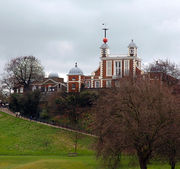
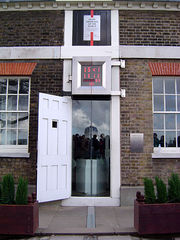
By international convention, the modern Prime Meridian passes through the Royal Observatory, Greenwich (at ), in southeast London, United Kingdom, known as the International Meridian or Greenwich Meridian, although the Prime Meridian is ultimately arbitrary unlike the parallels of latitude, which are defined by the rotational axis of the Earth with the Poles at 90° and the Equator at 0°.
Historically, various meridians have been used, including four different ones through Greenwich.
Contents |
Geography
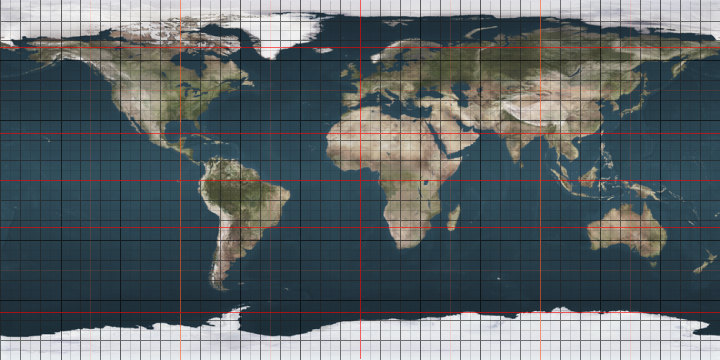
Starting at the North Pole and heading south to the South Pole, the Prime Meridian passes through:
-
Co-ordinates
(approximate)Country, territory or sea Notes Arctic Ocean The North Pole Greenland Sea Norwegian Sea North Sea  United Kingdom
The northernmost land on this meridian is near Tunstall in East Riding,Yorkshire.
The southernmost land in the UK is Peacehaven, East Sussex.English Channel  France
 Spain
SpainMediterranean Sea Gulf of Valencia SpainMediterranean Sea  Algeria
 Mali
Mali Burkina Faso
 Togo
TogoFor about 600 m  Ghana
GhanaFor about 16 km TogoFor about 39 km GhanaPassing through Lake Volta at Atlantic Ocean Passing through the Equator at Southern Ocean Antarctica Queen Maud Land, claimed by  Norway to the South Pole at
History
The Prime Meridian is ultimately arbitrary—a matter of convention—and various conventions have been used or advocated in different regions and throughout history:
- Washington, D.C. (77° 3' 2.3” W), see Washington meridian
- Philadelphia (75° 10' 12” W)
- Rio de Janeiro (43° 10' 19” W)[1]
- El Hierro (Ferro), Canary Islands (18° 03' W), later redefined as 17° 39' 46”? W)[2]
- Lisbon (9° 07' 54.862” W)
- Madrid (3° 41' 16.58” W)
- Paris (2° 20' 14.025” E), see Paris Meridian
- Brussels (4° 22' 4.71” E)
- Bern (7° 26' 22.5” E)
- Pisa, Italy (10°24' E)
- Oslo (Kristiania) (10° 43' 22.5” E)
- Rome (12° 27' 08.4” E), meridian of Monte Mario
- Copenhagen (12° 34' 32.25” E) Rundetårn
- Stockholm (18° 3' 29.8” E), at the observatory
- Warsaw (21° 00’ 42” E), see Warsaw meridian
- Oradea, Romania (21° 55' 16” E)
- Alexandria (29° 53' E)[3]
- Saint Petersburg (30° 19' 42.09” E), Pulkovo meridian
- Great Pyramid of Giza (31° 8' 3.69” E), 1884 [4]
- Jerusalem (35° 13' 47.1” E), for the small dome of the Church of the Holy Sepulchre
- Approximately 59° east of Greenwich [5]
- Ujjain (75° 47' E), Used from 4th century CE Indian astronomy and calendars.
- Kyoto (135° 74' E), Used in 18th and 19th (officially 1779-1871) century Japanese maps. Exact place unknown, but in "Kairekisyo" in Nishigekkoutyou-town in Kyoto, then the capital.
The modern Greenwich Meridian, based at the Royal Observatory, Greenwich, was established by Sir George Airy in 1851. By 1884, over two-thirds of all ships and tonnage used it as the reference meridian on their maps. In October of that year, at the behest of U.S. President Chester A. Arthur, 41 delegates from 25 nations met in Washington, D.C., USA, for the International Meridian Conference. This conference selected the Greenwich Meridian as the official Prime Meridian due to its popularity. However, France abstained from the vote and French maps continued to use the Paris Meridian for several decades.
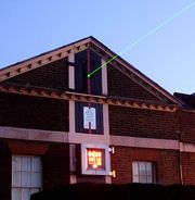
The Greenwich Meridian is now marked at night by a laser beam emitted northwards from the observatory.
IERS Reference Meridian
The International Earth Rotation and Reference Systems Service (IERS) maintains the IERS Reference Meridian (IRM), also called the International Reference Meridian, which is the reference meridian (Prime Meridian, 0° longitude) of the Global Positioning System operated by the United States Department of Defense, and is the reference meridian in WGS84 and in its formal versions, the ideal International Terrestrial Reference System (ITRS) and its realization, the International Terrestrial Reference Frame (ITRF). It is 5.31″ east of Airy's transit circle or 102.5 metres (336.3 feet) at the latitude of the Royal Observatory, Greenwich.[6] This shift is a legacy of the first satellite navigation system, the Doppler based TRANSIT system developed by the Applied Physics Laboratory of Johns Hopkins University in Howard County, Maryland.[7] This was the location of its first ground station, so the surveyed coordinates of that ground station in the North American Datum 1927 (NAD27), a non-Earth centered ellipsoid, became its coordinates in an Earth-centered ellipsoid, such as the World Geodetic System. This caused the coordinates of any other location on an Earth-centered ellipsoid to shift, especially those far away. When the antenna of a TRANSIT ground station was mounted directly above Airy's transit instrument in June 1969, its longitude on an Earth-centered ellipsoid was 5.64″ west of TRANSIT's reference meridian.[7] Further improvement in gravitational models, such as the Earth Geopotential Model 1996 (EGM96), and a dramatic increase in the number of ground stations from only four to over 500, as well as the use of time based GPS caused a small additional shift before it reached its present position.
The International Hydrographic Organization adopted an early version in 1983 for all nautical charts.[8] It was adopted for air navigation by the International Civil Aviation Organization on 3 March 1989.[9] Because tectonic plates slowly move over the surface of the Earth, most countries have adopted a version of the IRM for their maps that is fixed relative to their own tectonic plate as it existed at the beginning of a specific year, such as the North American Datum 1983 (NAD83), the European Terrestrial Reference Frame 1989 (ETRF89), and the Geocentric Datum of Australia 1994 (GDA94). Versions fixed to a tectonic plate differ from the global version by at most a few centimetres.
However, the IRM is not fixed to any point on Earth. Instead, all points on the European portion of the Eurasian plate, including the Royal Observatory, are slowly moving northeast about 2.5 cm per year relative to it. This IRM is the weighted average in the least squares sense of the reference meridians of the hundreds of ground stations contributing to the IERS network, including GPS stations, Satellite Laser Ranging (SLR) stations, Lunar Laser Ranging (LLR) stations, and the highly accurate Very Long Baseline Interferometry (VLBI) stations.[10] The coordinates of all of these stations are adjusted annually until there is no net rotation relative to the major tectonic plates. If Earth had only two hemispherical plates moving relative to each other around any axis from that intersecting their centres to one intersecting their junction, the longitudes (around any other rotation axis) of any two stations diametrically opposite each other must move in opposite directions by the same amount.
Universal Time is notionally based on the WGS84 meridian. However, the standard international time UTC can differ from the mean observed time on the meridian by up to 0.9 second (equivalent to about 260 metres at Greenwich), because of changes in the Earth's rotation. Leap seconds are inserted periodically to keep UTC close to Earth's angular position relative to the Sun — mean solar time.
United Kingdom Ordnance Survey Zero Meridian
The zero meridian used by the Ordnance Survey (OSGB36 datum) is about six metres to the west of the Airy meridian marked at Greenwich. When the first Ordnance Survey map was published in 1801, the official Prime Meridian of Great Britain was the one established by the third Astronomer Royal, James Bradley. When Airy's new Prime Meridian ("new" by virtue of Sir George Airy's instrument being placed in a room next to that housing James Bradley's instrument) superseded it fifty years later in 1851, the Ordnance Survey simply continued to use Bradley's.[11]
Other planetary bodies
Like on Earth, Prime Meridians must be arbitrarily defined. Often a landmark such as a crater is used, other times a Prime Meridian is defined by reference to another celestial object, or by magnetic fields. The Prime Meridians of the following planetographic systems have been defined:
- The Prime Meridian of the Moon lies directly in the middle of the face of the moon visible from Earth and passes near the crater Bruce.
- The Prime Meridian of Mars is defined by the crater Airy-0.
- The Prime Meridian of Venus passes through the central peak in the crater Ariadne.[12]
- Two different heliographic coordinate systems are used on the Sun. The first is the Carrington heliographic coordinate system. In this system, the Prime Meridian passes through the center of the solar disk as seen from the Earth on 9 November 1853, which is when Richard Christopher Carrington started his observations of sunspots.[13] The second is the Stonyhurst heliographic coordinates system.
- Jupiter has several coordinate systems because different latitudes rotate at different rates.[14] Scientific Astronomer uses System II coordinates, based on the mean atmospheric rotation of the north and south Equatorial belts. System III coordinates use Jupiter's magnetic field.
- Titan, like the Earth's moon, always has the same face towards Saturn, and so that face is 0 longitude.
See also
- 1st meridian east
- 1st meridian west
- Greenwich Mean Time
References
- ↑ Atlas do Brazil, 1909, by Barão Homem de Mello e Francisco Homem de Mello, published in Rio de Janeiro by F. Briguiet & Cia.
- ↑ Ancient, used in Ptolemy's Geographia. Later redefined 17° 39' 46” W of Greenwich to be exactly 20° W of Paris. French "submarin" at Washington 1884.
- ↑ The meridian of Ptolemy's Almagest.
- ↑ Wilcomb E. Washburn, "The Canary Islands and the Question of the Prime Meridian: The Search for Precision in the Measurement of the Earth"
- ↑ Maimonides, Hilchot Kiddush Hachodesh 11:17, calls this point אמצע היישוב, "the middle of the habitation", i.e. the habitable hemisphere. Evidently this was a convention accepted by Arab geographers of his day.
- ↑ History of the Prime Meridian -Past and Present
- ↑ A manual on the technical aspects of the United Nations Convention on the Law of the Sea - 1982PDF (4.89 MB) Section 2.4.4
- ↑ WGS 84 Implementation Manual page i, 1998
- ↑ IERS Conventions (2003): Conventional Terrestrial Reference System and FramePDF (419 KB)
- ↑ Charles Jennings; "Greenwich: The Place Where Days Begin and End", Little, Brown; 1999; p. 181
- ↑ "USGS Astrogeology: Rotation and pole position for the Sun and planets (IAU WGCCRE)". http://astrogeology.usgs.gov/Projects/WGCCRE/constants/iau2000_table1.html. Retrieved 22 October 2009.
- ↑ "Carrington heliographic coordinates". http://www.encyclopedia.com/doc/1O80-Carringtonheligrphccrdnts.html.
- ↑ "Planetographic Coordinates". http://documents.wolfram.com/applications/astronomer/AdditionalInformation/PlanetographicCoordinates.html. Retrieved 2009-06-19.
External links
- The Prime Meridian line at The Royal Observatory in Greenwich
- International Conference Held at Washington for the Purpose of Fixing a Prime Meridian at Project Gutenberg
- scanned TIFFs of the conference proceedings
- Prime meridians in use in the 1880s, by country
- Canadian Prime Meridian
- A pictorial catalogue of meridian markers
|
||||||||||||||||||||||||||||||||
|
|||||